

| mars-news.de |
|
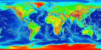 The new center computation is based on the digital elevation map
ETOPO2
with a resolution of 2', equivalent to 3.7km per pixel on the surface.
The new center computation is based on the digital elevation map
ETOPO2
with a resolution of 2', equivalent to 3.7km per pixel on the surface.
Using a simple numeric method for maximum search, called hill-climbing, the geographical center can be determined with one of todays common PCs within a few minutes.
The data source ETOPO2, which not only shows the contours of the continents, but also the elevation for each pixel in meters, and the offical abbreviation NOAA of the publisher, the National Oceanic and Atmospheric Administration, then induced to an experiment...
The sourcecode geocenter.c of the used algorithm.
| previous page | 6 / 10 | next page |
| © Holger Isenberg web@areo.info http://mars-news.de |
Updated 2nd edition published in 2025: Giza, Center of Earth? article on X |
last modified: 10/19/2003 published on: 10/19/2003 |