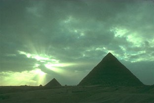
Where is the geographical center of all land-areas located?
Algorithm and data

last
last
next
next
home
home
deutscher Text

New article on same topic: Giza, Center of Earth


In the 19th century some archeologists (e.g. Peazzi Smyth, 1864, and Joseph Seiss) created the thesis that the Great Pyramid was built in the center of all land areas on Earth.

This theory appeared to be based on plane geometrics: They used for example, a special map-projection type for this calculation.

However, the correct calculation can only be achieved over great-circle distances on the sphere.

This trigonometric can be done with a simple algorithm as follows. For each point on Earth, the great-circle distance to all other raster-points in the map is measured and added. This sum is displayed as a color on the following map. Blue is selected for small distance-sums:


The center: 37.688 N, 35.438 E   (the historic place Iskenderun)
Pixel-Coordinates: 383x, 93y (from upper left).
The Great Pyramid: 30N, 31E.
Maybe a calculation with a better map moves the center 500km south, towards the Pyramid. But Iskenderun as center is not less interesting ;-)
The result projected on a 3D-Globe (VRML)

The geographic center is the point or the point set, which sum of all distances to all other points of the area has a minimum. On Earth surface, this distance is the arc length along the spherical great-circle between two points.

My algorithm: C-Program

As data source for the calculation, I used the NOAA 2-min digital elevation modell (DEM):


ETOPO2

Update:
The same calculation with a map of 4000x2000 pixel resolution, does not change the result very much. So this is neither a proof for the center-theory nor a proof against it. The calculated center is in relation to the length of the equator only about 1% away from the Great Pyramid, which speaks more pro the center-theory than against it!

The algorithm and some test-data


Holger Isenberg
web@areo.info

PGP-Key